Tracking migration In Haiti
In Haiti, cartographer Pressler Jean uses his UAV to track the migration of people displaced after the earthquake in 2010
Launching the UAV
On a hot, humid and blustery day on the outskirts of Port-Au-Prince, Pressler Jean keenly studies the map on his laptop. The program he is using to program his UAV is informing him that the conditions won’t be optimal for flying.
“It’s too windy,” he says, shaking his head and frowning.
Despite the warnings, the 29-year-old walks over to the case that contains the UAV he plans to fly. He reaches down and flips the latches keeping it closed. The lid opens with a click, and he pulls out the pieces of UAV he will be launching.
He first he slides the wings into place. Next comes the rudder and nose propeller. Finally, he turns on a small digital camera before inserting it into a compartment in the UAV’s body. Jean briefly checks his laptop and types in a few more coordinates before walking out into the middle of the field to launch the aircraft.
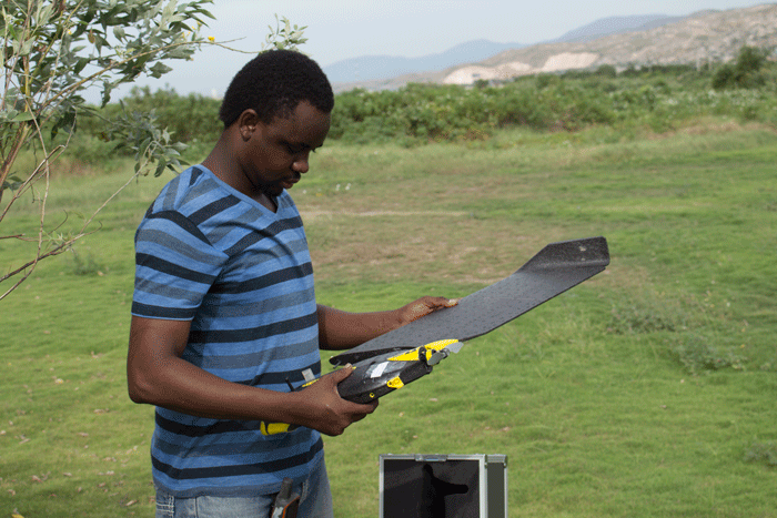
Pressler Jean assembles his UAV for a mapping flight over Canaan. Photo © Matthew Allen.
He looks up. It doesn’t look like the wind will be calming anytime soon.
“We’ll still give it a try,” he says with a shrug.
“If anything goes wrong, the UAV will come back.”
Three shakes and the UAV jolts to life with a beep, the propeller attached to its nose beginning to spin. Jean positions himself to launch the UAV facing into the wind, helping the plane’s wings achieve maximum lift. Then, in one smooth motion, he casts his tool into the air.
After pausing for a few moments to make sure that the UAV has successfully begun its flight, Jean walks back to the laptop. He taps the laptop anxiously and frowns. Just as he suspected, the wind will be cutting his flight short, and he won’t be able to gather the pictures necessary to complete the day’s mapping.
The UAV flies back on the same path that it was launched, sliding to a smooth halt on the lush Haitian grass. Jean runs out to collect the machine, and downloads what precious data he was able to gather into his laptop.
“This happens sometimes,” he says. “We’ll have to come back tomorrow.”
Maps telling a story
Jean is a Haitian cartographer. He is humble and gracious, wearing worn jeans and a faded polo shirt as he flies his UAV over a scorched stretch of desert land just outside of Port-Au-Prince called Canaan. While in the air, the UAV takes pictures of the land which are stitched together with special software to make maps that are archived for analysis.
Most of the people who Jean is trying to help don’t understand what he is doing or why his research is important. And who can blame them. It might not be immediately apparent why a map-making UAV is a critical piece of an effort to bring development to a mountainside slum. For the most part, UAVs are either conceptualized as military tools used for surveillance and tactical strikes, or as toys for hobbyists to collect aerial footage.
However, in development contexts maps can tell aerial stories, and can capture trends that may be hard to quantify on the

Aerial view of the Canaan settlement capture by sensefly drone in 2014
ground. The story of Canaan that Jean is trying to capture offers a small window into a community still reeling from the effects of the natural catastrophe that shook Haiti to its core. In many ways it tells a larger story about the path Haiti has taken since the 2010 earthquake.
The magnitude seven quake ripped through Port-Au-Prince, killing over 160,000 people and displacing millions more. The world rallied around the country, pouring millions of dollars of aid and assistance to help the country recover. But six years later, many of the people who were supposed to be helped back onto their feet are still rebuilding their lives. The people who live in the Canaan community where Jean is flying his UAV are living this reality every day. In the aftermath of the earthquake, people who couldn’t find places to live in the city moved to scrubland that nobody else had claim to or wanted.
“After the earthquake, people were looking for any way to not be under a concrete roof,” says Marylynn Steckley, an aid worker and researcher who spent six years in Haiti before and after the earthquake.
Small camps turned into settlements, and over time, these settlements have become small towns occupied by thousands of people who have nearly no support. There is no plumbing, no waste disposal and very little power.
The UAV that Jean has been using to document all of this was developed in partnership with a Swedish UAV manufacturer called Sensefly. The company was looking for a way to field test their product and collaborated with Jean and his team to develop the software and refine the body of the UAV for use in Canaan. Once the testing was complete, the company left the UAV with Jean so that he could continue the work that he is currently doing, and he’s been tracking the migration of people to Canaan ever since.
He works for the International Organization for Migration in Haiti (IOM), an international organization that monitors the flow of people both between and within state borders. In Haiti, IOM has been tracking the movement of people displaced from Port-Au-Prince by the earthquake. Before 2010, IOM had only a dozen employees, but by the end of the year, the agency employed over 70 employees, needing more manpower to fully understand where people were going. So far he’s been able to conclusively prove a steady increase in the population of the last six years. In 2012, there were 2100 homes in Canaan. By 2014, that number had risen to over 2700. Jean hopes that by showing the population growth and dangerous living conditions in the area, he can bring help to the people who live in these areas from the government. So far, it’s been a frustrating endeavour.
No plan, no hope
As Jean drives through Canaan itself, waving to the people in the community that he has come to know, he explains that the people who live in the area live there out of necessity, not choice. There was no direction from the government as to how or where people should go.
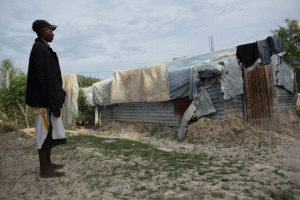
Haitian villager looks at a home that was recently flooded in Canaan. Photo © Matthew Allen.
“People didn’t plan anything before they came here,” he says.
“They had nowhere to go, so they just built homes wherever they could.”
This lack of planning has resulted in a desperately poor town that looks like it belongs in the 19th century. There are no roads in Canaan, only dirt tracks pocked with potholes the size of small bathtubs. The homes in the settlement are rudimentary at best. Constructed out of concrete blocks with tin roofs, they are small, cramped, single roomed structures that provide no relief from the elements. It’s no place to raise a family, but the people living there have no choice.
Jean continues driving until he spots a home and pulls over to talk to the woman, DuVillage Sidonia, who lives inside. Sidonia, 39, is a short, heavy set Haitian with a handsome face. As she exits her house, she calls out to two boys who are playing soccer further along the pathway.
“She wants them to come inside before it gets dark,” Jean explains.
Sidonia is an example of someone who has been forced to live in Canaan since the earthquake. A jewelry maker who sells embroidery in Port-Au-Prince to support her two sons, Sidonia has lived in the Canaan settlement for nearly five years. Her home, like so many others was built without forethought or planning. It’s located in a flood plane, and when it rains heavily, the single room space quickly turns into a small swimming pool. All she can do is stand on her bed and wait for the water levels to go down.
“My kids are terrified of the water,” she says.
“They’re really scared. All we can do when it comes it stand on our bed until it’s gone.”
Sidonia said that she only wants her children to have a safe place to live where they can go to school and learn. A portion of the money she makes pays for their education at the small primary school a little further up the mountain, but when the area is flooded, she is forced to keep them at home.
“I just hope that the government will help us and build canals to stop the flooding,” she says.
Waiting for help
Despite the difficulty and hardship of living in a place like this, Sidonia and others like her take pride in the homes they’ve built. It isn’t much, but it’s theirs. All they want is some help with the basics to make life a bit easier.
Waiting for help is a position a lot of these residents have been forced into since they moved here. What else can they do? They are poor, and don’t have the means to fix their own problems. They are heavily dependent on those in positions of power to take action, but they aren’t expecting much to come.
“When you’re leading a community like this, there’s so much that you want to do, but there are so many obstacles preventing you from accomplishing what you want to accomplish,” says Francis Valmy, one of the leaders of the community who is also the principle of the local school.
“The government doesn’t care about people who are poor.”
The government in Haiti hasn’t addressed the dilemma of some of its most disenfranchised. In fact, many scholars argued that the lack of government oversight is what created the conditions that made the earthquake so devastating. In the 1960s, policies of centralization were implemented in Port-Au-Prince with the aim of bringing industrialization and employment to the city. Thousands of people migrated from the country’s rural areas to its urban center in hope of finding a better life. But for many of them promises of work and wages went unfulfilled, and a lack of government oversight in the city resulted in a massive concentration of people living in low quality housing.
“My kids are terrified of the water”
– Sidonia Duvillage, Haitian villager.
“With no real administration or building codes, people basically built shanty towns on steep hillsides that were vulnerable to hurricanes and earthquakes,” says Steckley.
Building for the future
On the drive back to Port-Au-Prince Jean tries to explain why he is trying so hard to produce this data even when it seems futile in the face of persistent civil unrest and government indifference. He points to the fact that conditions that existed prior to the earthquake are being recreated all over the country. The lack of planning that led to Port-Au-Prince being so devastated is also contributing to the desperate conditions that Sidonia and her children are living under. Professionals like Jean see the same mistakes being repeated, and he doesn’t want the same tragedies to repeat themselves. Maybe by raising awareness, and putting enough evidence in front of the people who can make the real decisions, they can be a force for real change.
“What if another earthquake happens?” he asks.
“Things haven’t changed at all since 2010. People are still living the same way they did before. If anything things are worse in some places.”
But there is another motivation behind Jean’s work. In addition to the procedures and processes that exist and drive urban planning in the developed world, there are also existing bodies of institutional knowledge. There are generations of civil engineers, cartographers and city planners who collaborate with governments to make sure that towns and cities are developed correctly. This tradition doesn’t exist in Haiti, and it’s hard to make changes in the present when the institutional memory isn’t established enough to learn from the development mistakes of the past.
“In Haiti, there is a lot of information,” says Jean on the drive home from Canaan, “but taking it and acting on it is the difficult part. We are doing this to share with people and government so good decisions can be made.”
Even if Canaan isn’t fixed, Jean hopes that the record he leaves will be a foundational block that future Haitian scholars can build upon. Now that he has done his work, a blueprint exists in Haiti for using UAV technology as a mapping tool in the future. It’s a small start, but lasting development takes decades.
So despite the difficulty and frustration, Jean will return to the field and launch the UAV again.
Someday, the winds might change.
Header photo © Matthew Allen.
More Applications

Search and rescue in Nepal
Canadian relief agency Global Medic
using drones to coordinate its search
and rescue efforts overseas

Monitoring poaching in South Africa
In South Africa, non-profit Global Medic
is Using UAVs to stop poaching